
|

Monticello Water Repairs

  

 Monticello


Deteriorating Water System: Where Do I Start?Leak1
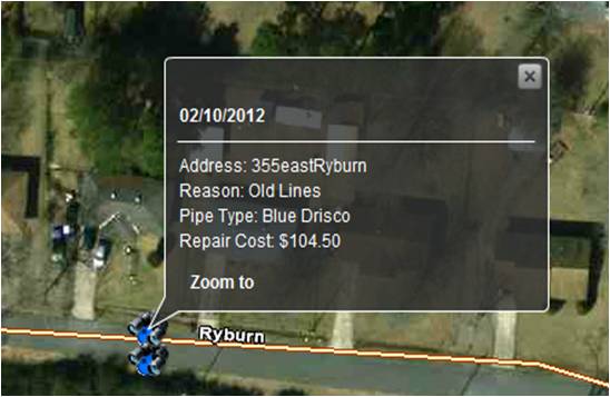
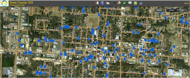
Upon election the Mayor of Monticello, Allen Maxwell, quickly realized the issue he inherited with a deteriorating water system.  For many years Monticello Water Department Employees were tasked daily with patching the leaking water system.  Mayor Maxwell envisioned a system where he could quickly and easily visualize where the water leaks were occurring so he could make a case for the replacement of the old deteriorating pipes.  Through a partnership with a local GIS company, EFS GeoTechnologies, the two entities began developing the system below. The Monticello Water Repairs database was developed with the EFS’ EDGE GIS.  EDGE allows for quick, easy visualization and analysis of the water leak locations mapped by Monticello Water Department Employees using EFS’ EDGE for Field Data Collectors solution.  This allowed the visualization of the data for replacement of pipes instead of patching and ultimately led to making a case for the replacement of Monticello’s old water system.


EDGE2

60% 0f leaks in 19% of City Area.


Results:

  • Magnitude of Leak Problem Realized
  • Targeted Areas for Line Replacement versus Leak Repair
  • Following a comprehensive 2 year study, the City entered into a $10 Million Performance Contract with Siemens Industry, Inc to upgrade the Water System
  • Additonal Projects: Utilized EDGE for Fire Hydrants, Bulk Trash Dumpsters, Trash Truck Routing & Airport Obstructions


EFS GeoTechnologies is an Aerial Photography and GIS Services company based in Monticello, Arkansas. To learn more about EFS please visit www.EFSGEOTECH.com.  Also, to receive updates from EFS you can follow them on Facebook and Twitter.

Similar Posts

  • Dabney Reappointed to AR State GIS Board

    The Arkansas Geographic Information Office (AGIO) announced Wednesday Glen E. Dabney, R.F., A.C.F. President of EFS GeoTechnologies, was appointed to a second term on the Arkansas GIS Board by Governor Mike Beebe.  The Arkansas GIS board, comprised of twelve members from state and local government, the private sector, and institutions of higher education, works with the AGIO to coordinate…

  • Levi Hayes Joins EFS Team

    April 2, 2018 – Levi Hayes accepted a position with EFS as Pilot for EFS’s Aerial Photography Team.  In addition to his aerial photography collection responsibilities, Levi has been assisting the Image Processing Team when not in the air.  Born and raised in Van Buren, AR, Levi received a B.S. in Aviation, Professional Pilot Track with…

  • Professional Surveyor Magazine Aerial Mapping

    The current issue of Professional Surveyor Magazine features a case study of EFS GeoTechnologies. “The challenges of operating a successful aerial survey firm are many – inclement weather, scheduling challenges, tight deadlines, and the occasional buzzard…” Download the PDF here, or read the full article online at: http://www.profsurv.com/magazine/article.aspx?i=70651&p=1

  • 2015 EFS Company News Update

    Aerial Photography The EFS Image Processing Team has completed all Winter Mapping Projects from the 2014-2015 season and are currently working on summer/fall forestry site prep imagery as well as getting prepared for the 2015-2016 Winter Mapping Season which will begin around the middle of December. EDGE The EDGE team has been busy presenting EDGE…